In my previous post about William Munford Stubbs, I shared that the Y-DNA results for this objective revealed two different surnames: Dale and Brock. Could one of these surnames have been William’s father’s surname too? The next step in my attempt to learn the name of William’s father was to identify Dale and Brock families living in close proximity to Ann Munford and her family at the time William would have been conceived. Tracing the families forward in time could lead to Y-DNA test takers who could be invited to test. If one or more of them match my Y-DNA test taker, then I could conclude that that test taker’s family is the correct ancestral line and then do further research on that family to attempt to focus in on a particular candidate.
I chose to use census records to identify Brock or Dale families living in the area between 1851 and 1861. Census records have been taken in England every ten years beginning in 1801. Records from 1841 through 1921 list every member of the household and provide additional information that can help distinguish individuals of the same name, including exact birthplaces and occupations. The 1851 and 1861 censuses could provide the names of Brock and Dale families who lived near the Munford family’s residences of Wymondham and Hethel, where Ann gave birth to William. She may have been living there when William was conceived. For this project iteration, I chose to look at families who lived within five miles of these communities (see map below). I also decided that men who would have been between the ages of twenty and forty-five in 1857 (born between 1812 and 1837) would be the most likely candidates. Ann would have been twenty-five at the time.
To create the map below as a guide for my research, I accessed a map of the 1851 England census jurisdictions at FamilySearch. I took a screen shot with Wymondham and Hethel in the center. I opened the screen shot in Paint 3D (a free Windows program) and marked Hethel and Wymondham. I then went to Google maps and found where Wymondham and Hethel were on a modern map, then used the measuring tool provided by Google Maps to see where five miles fell from both of these locations to get some reference points. I used those reference points to draw a circle on the jurisdiction map with a radius of roughly five miles.
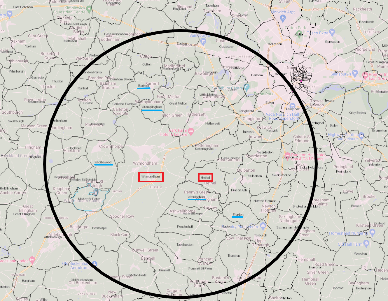
The areas within five miles of Wymondham and Hethel fall largely within the Forehoe and Henstead registration districts. Areas south of Wymondham, Wreningham, and Flordon are in the Depwade registration district. Research during this session focused on the Forehoe and Henstead registration districts. Brock and Dale families in Depwade can be examined in a future research session.
No Brock men of the correct age were found to be living in the Forehoe and Henstead registration districts between 1851 and 1861.1 Several Dale men lived in the area during this period:
- In 1851, James Dale, a single man born in 1826 in Wramplingham, lived in Wramplingham.2 Wramplingham is four miles north of Wymondham.
- In 1851, Charles Dale (born in 1834), was a pauper living in the workhouse in Wicklewood.3 At seventeen, he may have been the son of fifty-three-year-old Elizabeth Dale, who also lived in the workhouse.
- In 1851, Robert Dale, an agricultural laborer of Wreningham who was born about 1802 in Bracon Ash, was enumerated with two sons: John (born in 1827) and Robert (born in 1837).4 Wreningham borders both Wymondham and Hethel. A third son, William (born in 1844), would have been too young to have fathered William Munford in 1857.
- In 1851, Noah Dale, an agricultural laborer of Flordon who was born about 1807 in Bracon Ash, had a son John who was born in 1837.5 Flordan borders Hethel and Wreningham.
- In 1861, Robert Dale, an agricultural laborer of Flordon who was born in Hethel, had two sons aged eighteen and sixteen.6 He also had a twenty-two-year-old daughter named Elizabeth living in his household. All the children were born in Wreningham. Similar information for the two families suggest that this could be the same Robert Dale who lived in Wreningham in 1851, even though their birthplaces differ. One of the birthplaces could be incorrect.
- In 1861, Thomas Dale, a gardener who was born in Wreningham in 1814, lived in Flordan.7 He was married with children during the period when William was conceived, and was therefore not as likely a paternal candidate for William Munford Stubbs, although he can’t be completely eliminated.
- In 1861, James Dale, an agricultural laborer born in 1826 in Wramplingham, lived with his wife Elizabeth in Wramplingham.8 The couple appears to have not had any children.
While census records located Dale individuals in the area in 1851 and 1861, locating men who lived in the five-mile range of Wymondham and Hethel in the specific year of 1857 would be most helpful, since William was born in June 1858. Electoral registers were created each year and might provide evidence for Brock or Dale men in the area in 1857. However, it is estimated that these records cover only eleven percent of the population, so many paternal candidates could be missing from the collection.
No Brock men appeared in the electoral registers in the Forehoe or Henstead registration districts between 1851 and 1861.9 Only one Dale man, John Dale, appeared in the registers. He was registered in Hapton in 1858-1860.10 Could this have been the son of Robert Dale, enumerated in Robert’s household in 1851? This is a question that would require further research.
Of the Dale families living within a five-mile radius of Wymondham and Hethel, Robert Dale of Wreningham was one of the closest. Wreningham lies between the two localities of Wymondham and Hethel. Additionally, he had at least two sons who can be considered paternal candidates for William Munford Stubbs. His was the first Dale family I decided to study during this research session. Further information about the family will be the subject of my next blog post.
- “1851 Census of England,” database with images, Ancestry (https://www.ancestry.com/search/collections/8860/ : accessed 12 April 2023), negative search for Brock men living in the Forehoe or Henstead registration districts. And “1861 England Census,” database with images, Ancestry (https://www.ancestry.com/search/collections/8767/ : accessed 16 April 2023), negative search for Brock men of the correct age living in the Forehoe and Henstead registration districts.
- “1851 England Census,” database with images, Ancestry (https://www.ancestry.com/discoveryui-content/view/5188918:8860 : accessed 25 April 2023) > Norfolk > Wramplingham > ALL > 14 > image 9, p. 9, no. 40, James Dale.
- “1851 England Census,” database with images, Ancestry (https://www.ancestry.com/discoveryui-content/view/5190027:8860 : accessed 25 April 2023) > Norfolk > Wicklewood > ALL > Workhouse for the Poor of the Incorporated Parishes of the Hundred of Forehoe > image 7, p. 194, Charles Dale.
- “1851 England Census,” database with images, Ancestry (https://www.ancestry.com/discoveryui-content/view/5201561:8860 : accessed 2 May 2023) > Norfolk > Wreningham > ALL > 9 > image 6, p. 5, no. 17, household of Robert Dale.
- “1851 England Census,” database with images, Ancestry (https://www.ancestry.com/discoveryui-content/view/5203871:8860 : accessed 2 May 2023) > Norfolk > Flordon > ALL > 19 > image 4, p. 22, no. 6, household of Noah Dale.
- “1861 England Census,” database with images, Ancestry (https://www.ancestry.com/discoveryui-content/view/17382521:8767 : accessed 2 May 2023) > Norfolk > Flordon > All > District 1 > image 2, p. 10, no. 3, household of Robert Dale.
- “1861 England Census,” database with images, Ancestry (https://www.ancestry.com/discoveryui-content/view/17382584:8767 : accessed 3 May 2023) > Norfolk > Flordon > All > District 1 > image 5, p. 20, no. 30, household of Thomas Dale.
- “1861 England Census,” database with images, Ancestry (https://www.ancestry.com/discoveryui-content/view/17372830:8767 : accessed 2 May 2023) > Norfolk > Wramplingham > All > District 8 > image 11, p. 11, no. 57, household of James Dale.
- “Norfolk, England, Register of Electors, 1832-1915,” database with images, Ancestry (https://www.ancestry.com/search/collections/9860/ : accessed 21 April 2023), negative search for Brock between 1851-1861.
- “Norfolk, England, Register of Electors, 1832-1915,” database with images, Ancestry (https://www.ancestry.com/discoveryui-content/view/930857:9860 : accessed 2 May 2023) > Norfolk > Eastern division > 1858, image 97, entry for John Dale of Hapton. Also “Norfolk, England, Register of Electors, 1832-1915,” database with images, Ancestry (https://www.ancestry.com/discoveryui-content/view/3321470:9860 : accessed 2 May 2023) > Norfolk > Eastern division > 1859, image 102, entry for John Dale of Hapton. And “Norfolk, England, Register of Electors, 1832-1915,” database with images, Ancestry (https://www.ancestry.com/discoveryui-content/view/785501:9860 accessed 2 May 2023) > Norfolk > Eastern division > 1860, image 217, entry for John Dale of Hapton.
Hi Alice
I haven’t run across the families you’re working on. but I am most impressed by your research.
I’ll definitely stay in touch. Thank you so much for sending the information that you have -as I do research for the Demery family, I will certainly look for the Dale and Stubbs family.
Best regards