Two weeks ago in my Research Like a Pro with DNA study group we worked on locality research. The ancestors I am currently researching immigrated from Galicia, which was a part of the Austro-Hungarian Empire from 1815-1918, to Cohoes, New York. They then migrated to Lorain County, Ohio. I had already created Locality Guides for Galicia and Lorain County, and as I worked on my timeline analysis and looked at the trees of DNA matches for this project, I realized that although the ancestor was only in Cohoes, New York for 3-4 years, several of the ancestor’s family members also immigrated to Cohoes, New York and stayed. I decided I needed to create a locality guide for Cohoes, New York. This guide will help me build trees for some of the ancestor’s DNA matches, which will be very beneficial as I try to connect all the dots in this case.
Part of creating a locality guide is to learn about migration routes through the area. How might our ancestors have traveled to or through this locality? My case does include migration, so this part of my guide is important. The FamilySearch Wiki is a great place to learn more about migration routes. My first step is to look up the place for which I am creating my guide. The Cohoes, Albany County, New York page doesn’t include information about migration routes, but the Albany County page has a great section on migration routes:
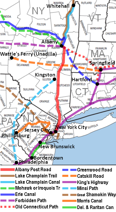
Migration routes for early European settlers to and from Albany County, New York included:
Hudson River: a navigable river stretching from north of Albany then flowing south to empty into the Atlantic Ocean at New York City
Albany Post Road from New York City to Albany, New York1669
Alford and Egremont (MA) Turnpike, 1812
Ancram (NY) Turnpike, 1805, also sometimes called the Catskill Road, from Salisbury, Connecticut to Catskill, New York
Catskill Road, 1750s, from Springfield, Massachusetts to Catskill, New York
Catskill Turnpike (aka Susquehannah Turnpike) from Catskill, NY to Unadilla, NY; route travelled by Europeans by 1792; toll booths opened by 1804.
Columbia (NY) Turnpike, 1799
Great Barrington and Aford (MA) Turnpike, 1812
Greenwood Road, 1799 from Hartford, Connecticut to Albany, New York
Hampden and Berkshire (MA) Turnpike, 1826
Hillsdale and Chatham Turnpike, 1805 from Alford, Massachusetts to Albany, New York
Housatonic River (MA) Turnpike, 1809
Massachusetts 10th Turnpike, 1800
Massachusetts 12th Turnpike, 1812
Mohawk or Iroquois Trail, 1722 from Boston, Massachusetts to Fort Oswego, New York
Rensselaer and Columbia (NY) Turnpike, 1799
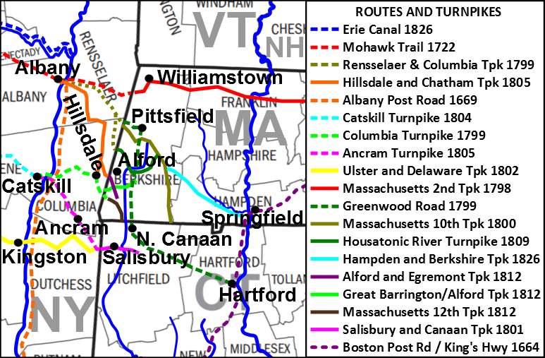
Hudson River pre-historic
Lake Champlain pre-historic
Champlain Canal 1823
Erie Canal 1825
Chambly Canal 1843
Richelieu River pre-historic
Saint Lawrence River prehistoric
Lake Champlain Trail pre-historic
The following maps are also included to aid visualization of these migration routes:
These resources were very helpful for my Cohoes locality guide. However, I have often found that the Wiki pages simply include a list of migration routes with links and I have to click each link to learn more about the routes, which can be tedious, especially when there are quite a few routes listed and I am not familiar with any of them. It’s hard to know which routes my ancestors might have taken without knowing where the routes begin and end.
Another page that has helped me solve this dilemma is the United States Migration page, also located in the FamilySearch Wiki. There are several great resources found on this page, including links to key U.S. migration databases and a tool for discovering pre-1850 migrations to each state.
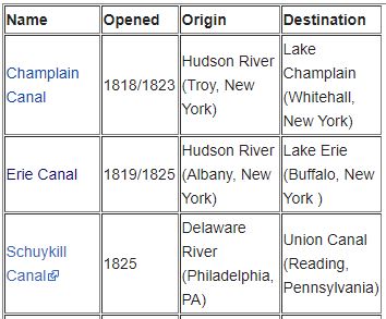
One of the tools on this page that I have found most helpful is in the upper left-hand corner of the page. Here you will see a list of U.S. Migration Routes, including canals, ports, railroads, rivers and lakes, and trails and roads. Clicking on any of these choices will bring up a chart of the major routes of each type with the date the route opened and the starting and ending points for each route. Here is a portion of the Chronological List of Most Significant United States Canals Used by Settlers:
Also included on this page is a great map that illustrates significant transportation canals in the United States:

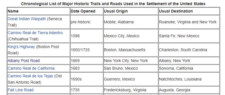
You can see from this snapshot the valuable information you will find on the Chronological List of Major Historic Trails and Roads Used in the Settlement of the United States:
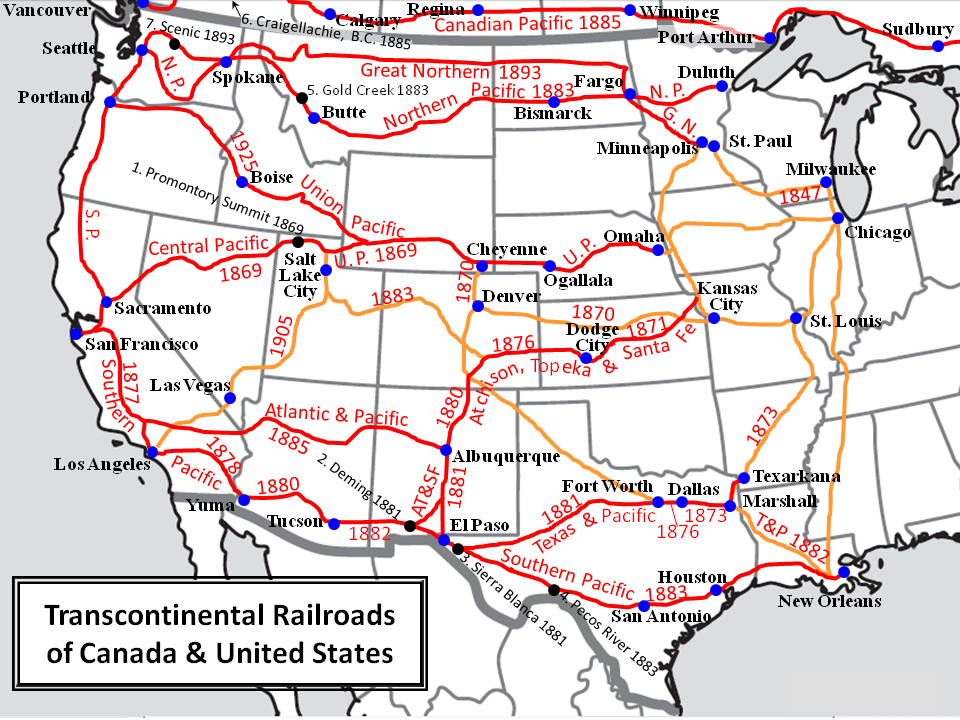
This map of Trancontinental Railroads of Canada and the United States, which includes start dates for each route is another great resource, and is located on the Railroads page under “U.S. Migration Routes.”
I’ve provided just a sampling of the great migration resources that are found on the US Migration page on the FamilySearch Wiki. It has so much more information including books, articles, and websites that will help you as you begin to try to discover migration routes for your ancestors.
I hope you will have fun exploring this great resource! What other resources have you discovered for learning about your ancestors’ migration? I would love for you to share your ideas in the comments below.
My 2X great grandmother and her 1st cousin/future husband (along with her four young children from her first marriage) traveled by covered wagon from Upstate New York to Dodge City, Kansas in 1884.
I don’t know if the entire trip was by covered wagon, but I know at least part of it was from what I learned from interviewing the daughter and granddaughter of one of the mentioned children.
I would love to know the route they took!