I spent last week in an institute course offered by the Salt Lake Institute of Genealogy titled Metes & Bounds Land Platting. It was a fantastic course and I’m excited to share a little bit about my experience.
First, a little bit about metes and bounds. The original thirteen colonies, along with Kentucky, Tennessee, Texas, and West Virginia are all “state land states.” This means that the states retained control of land distribution. In the rest of the states, the federal government was the entity that original settlers purchased land from.
In federal land states, the land was laid out using the rectangular survey system and divided by townships, ranges, and sections. This was not the case in state-land states, where parcels of land were claimed by settlers looking to acquire a piece of land that would be good for farming and hopefully included some kind of water access. They would mark off the land they wanted and then request that land from the government by submitting a petition or application. The government would then issue a warrant directing that the lands be surveyed. The surveyor would measure the land, and after this, a patent could be issued to the petitioner, which gave him the title to the land.
In the process of measuring the land, the surveyor created a land description that was usually very detailed and sounds quite foreign to those who have never seen one. Here is an example:
Beginning at the sixth station of the Said tract & from thence turning along the said Devenports line (1) south four degrees and forty five minutes east thirteen chains thence (2) South eighty one degrees and forty-five minutes east fourteen chains thence (3) north thirty seven degrees and thirty five minutes west twenty five chains & ten links and from thence (4) south four degrees and forty five minutes east five chains to the beginning containing twelve acres and thirty one hundredths of an acre strict measure.
Morris County Deeds A:133-35, Abraham Ogden to Jacob Devenport, written 20 June 1770, recorded 10 August 1787; images, FamilySearch (https://www.familysearch.org/ark:/61903/3:1:3Q9M-CSHM-6BLK : accessed 28 January 2023).
Deeds for subsequent sales of the same land usually retained the same land description. The SLIG course focused on teaching us how to interpret the metes & bounds descriptions in these land records and then “plat” or draw the boundaries of the land. We learned how to do this both by hand and by using a computer program called DeedMapper. We then learned how to place these plats on maps – both historic and modern maps.
The most-asked question when I told people I was taking this class was “Why do you need to know how to do that?” The first session of the class offered some “motivation.” Course instructor Jerry Smith provided some instances where land platting might be useful:
- Locating important landmarks like family cemeteries.
- Distinguishing same-name individuals.
- Placing the land on a modern map so family members can visit their ancestral properties.
- Determining whether two people are related when there is no direct evidence stating a relationship.
- Understanding the physical layout and geographic features of the land
- And more…..
The five-day course was packed with instruction the first two days with a lot of hands-on practicum time during the last three days. There were eleven practice problems that we spent time trying to solve. It was overwhelming at times, but also a lot of fun! I loved being able to practice what I was learning to solidify the concepts. I worked on practicum problems involving land in York, Perry, and Wetmoreland Counties in Pennsylvania, and on an urban platting problem in Wilmington, Delaware. I spent the last day of practicum time working on a couple of my own projects centering in Morris County, New Jersey, and Grafton County, New Hampshire.
In addition to learning the skills for platting metes & bounds and locating properties on maps, the instructors highlighted some really fun resources. Here are a few that helped me make discoveries about my own ancestors as I explored them over the week:
EarthPoint
EarthPoint is a site that provides tools for Google Earth. One of its features is Township and Range – Search by Description. This tool allows you to enter the State, Principal Meridian, Township, Range, and Section that your ancestor lived on and then click Fly to on Google Earth to view that parcel on Google Earth. To get the information needed for this tool, first search for your ancestors who received land grants from the federal government at the BLM General Land Office Records site. Enter the information obtained from the land patent into the search fields at EarthPoint and click the button.
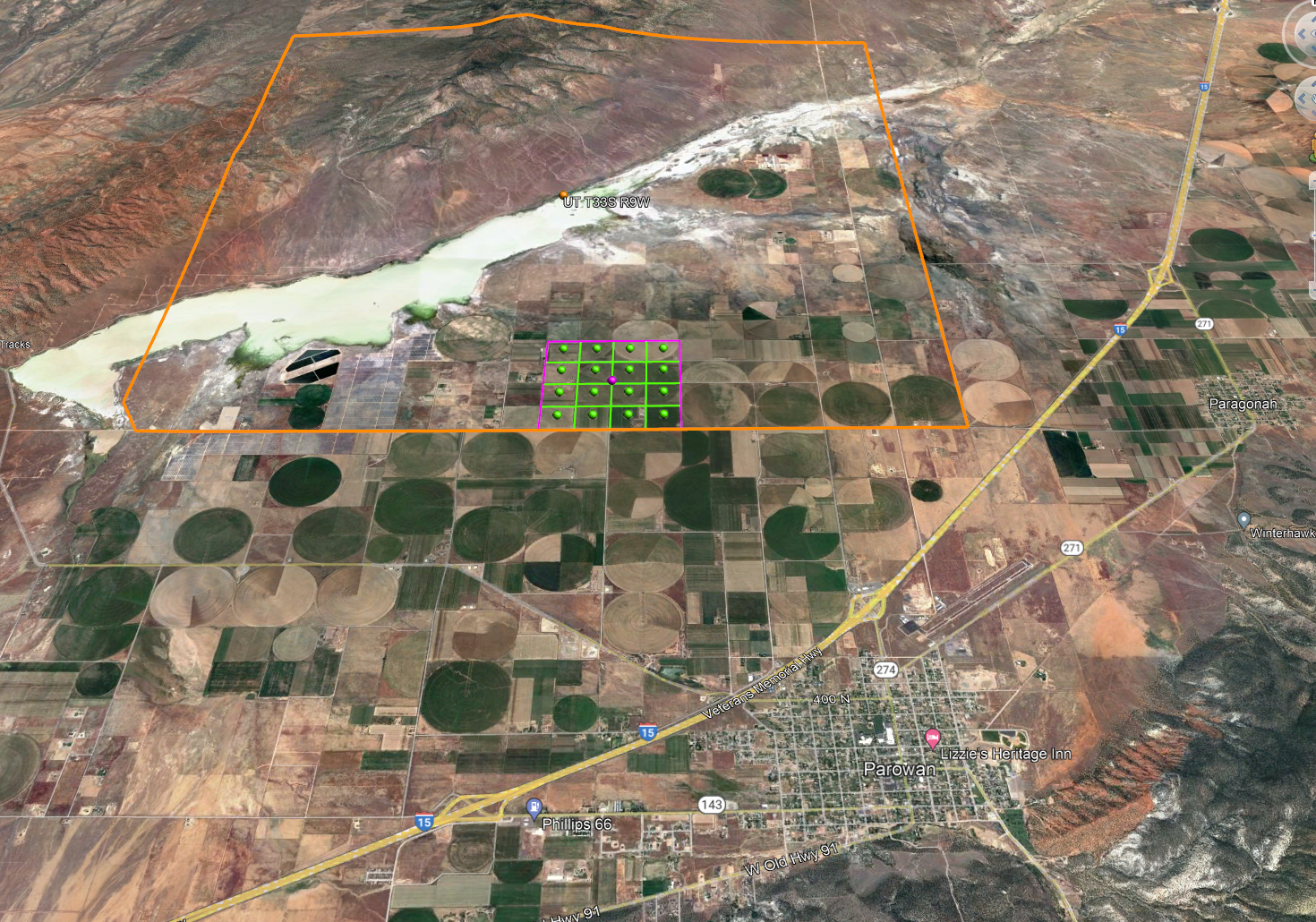
Several years ago, my family held a reunion in Parowan, Utah, the home of many of our ancestors. At the time, I wished I knew exactly where our ancestors had lived but I didn’t have the knowledge or skills to figure that out. I have since learned about finding land patents, and EarthPoint’s tool helped me see exactly where the land described in my ancestors’ patents is located. Here is what I found for the lands of Oscar W. Lyman and Edward Ward, two of my ancestors who lived in Parowan. It was fun to see where their land was in relation to the town itself. Note that you do need to have Google Earth Pro installed on your desktop computer to utilize this tool.
County Geographic Information Systems (GIS)
GIS combines a lot of data into one interactive map and can be a useful aid for many of the objectives I listed above. It was fun to explore GIS sites for counties of interest during this segment of our course.
Many of my husband’s ancestors lived in Westmoreland County, Pennsylvania. My four-generation project for accreditation centered on the Beck and Fisher families of Westmoreland County. The county has an amazing site that includes historic maps that show the original landowners of each township along with the GIS. When viewing the GIS, you can scroll in to view certain townships, then choose which layers you would like to view. One thing that particularly interested me was the filtering capability that allows users to turn the lines on to view the original patents in the county and turn off modern-day parcel lines. It was interesting to see how large parcels have changed and subdivisions have been created over time.
I also explored the Utah County GIS, since that’s where I live. The Parcel Map has similar functionalities as the Westmoreland County GIS, but with a different interface. One really cool thing about this GIS is that you can select a year and show the parcels at a specific point in time. It was fun to see how the land ownership in our subdivision changed over the years.
Resources from Local Historical Societies
On the last day of class, I wanted to plat the land that my Mason ancestors lived on in Monroe, New Hampshire. Monroe was created from Lyman in 1854, so when my ancestors lived there in the early 1800s, it was Lyman. However, their deeds did not contain the usual metes & bounds descriptions. They simply gave lot numbers and neighbors. I was thinking I would need to seek out subsequent deeds for their land and deeds for all the neighbors to be able to map their land.
Serendipitously, a fellow student shared about her work in New Hampshire and showed a map of Lisbon, which neighbors Lyman. I reached out to her and she connected me with a historian at the Lisbon Area Historical Society and also suggested checking out the state historical society. The state society has a historic map of Lyman that includes the names of my ancestors on lots six and eight – just what I was looking for! I have requested a digitized copy of the map and am excited to receive it! And, it turned out that the historian at the Lisbon Area Historical Society knows exactly where my ancestors’ land was located – she sent me a Google Earth link. In addition, she wrote a newspaper article about my ancestor Amasa Mason Lyman a decade ago when some of his descendants returned to Monroe to celebrate the 200th anniversary of Amasa’s birth. She graciously sent me a photocopy of the article. Another fun connection!

It has been a rich and rewarding week. I learned some valuable skills that will help me with future research projects and along the way, I was able to discover some fun things about my own family history.
Thank you for such a cogent explanation. I have always wondered what “metes and bounds” meant, never having come across it in my work. It appears that Canada used the system in Ontario and with drawing electoral districts. Focussing as I do on western Canada, it’s the Hudson’s Bay, Dominion Land, CPR land, and Crown land systems. However, now I know what this term means, I’ll have a better idea of what I’m reading if I come across it. Thank you again, Alice. Always a pleasure reading your work.
Well, you convinced me to take it the next time the course is offered – I was researching the course this afternoon, and your blog popped up in the search results! Well done!
Thank you, Kristin! It really is a fabulous course!